Arusha to Mwanza KM via Singida by Road/Distance from Arusha to Mwanza via Singida/Distance from Mwanza to Arusha via Singida
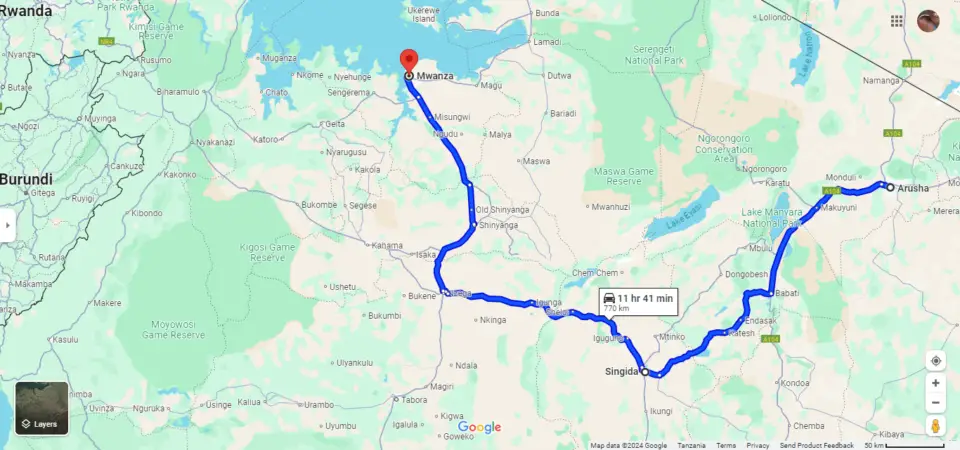
The Arusha to Mwanza km via Singida by road is 769 km, making it one of the longer overland routes between the two cities.
This distance is noticeably greater than the option that passes through the Serengeti, but it comes with practical advantages that many travellers prefer.
Taking the Arusha to Mwanza km via Singida by road allows for far more flexibility when it comes to departure times, overnight stops, and overall planning.
You avoid the strict entry hours, transit regulations, and conservation fees required when driving through both the Ngorongoro Conservation Area and the Serengeti National Park.
For drivers who want fewer restrictions, lower costs, and the freedom to travel at their own pace, the Singida route is often the more convenient choice despite the extra kilometres.
READ ALSO: Accurate Mwanza to Serengeti Distance 2025 & More
Table of Contents
Distance from Dodoma to Mwanza via Singida
The road distance from Dodoma to Mwanza via Singida is roughly about 660–690 km, depending on the exact route and measurement method.
Typical Travel Time
The driving time from Dodoma to Mwanza via Singida is usually around 10 to 11 hours without long stops.
How the Route Breaks Down
- Dodoma → Singida: roughly 230–250 km (about 3–4 hours).
- Singida → Mwanza: roughly 430–450 km (around 6–7 hours).
What the Route Is Like
- This is a major inland corridor across central and northern Tanzania.
- Roads are mostly paved, though conditions can vary in rural stretches.
- Common rest points along the way include Singida itself and sometimes Shinyanga before reaching Mwanza.
In short: if you’re travelling by road via Singida, expect roughly 670 km and about 10 hours of driving, depending on speed, stops, and road conditions.
Singida Arusha KM/Singida to Arusha KM
The distance between Singida and Arusha varies slightly depending on how you measure it and the exact route you take, but there are some clear, reliable ranges.
By road, the distance is generally about 320 km to 330 km.
Some route estimates put it slightly lower at around 318 km, especially when using the most direct driving path.
If you look at the straight-line (air) distance instead of the road distance, it is shorter, roughly 267 km to 269 km.
Travel Time
For most people traveling by road, the journey usually takes between 4 to 6 hours, depending on factors like road conditions, traffic, and the type of vehicle.
- A fast, uninterrupted drive can take just over 4 hours
- More typical travel, especially by bus or with stops, may stretch closer to 5–6 hours
What affects the distance and time
Even though the distance in kilometers stays fairly consistent, your actual experience can vary because:
- Road conditions in parts of central Tanzania can slow things down
- Different routes (via Babati or other towns) may slightly change total distance
- Public transport like buses often takes longer due to stops and passenger pickups
Quick summary
- Driving distance: about 320–330 km
- Straight-line distance: about 267–269 km
- Travel time: roughly 4–6 hours
So if you’re planning a trip between Singida and Arusha, expect a moderately long but very manageable road journey across central to northern Tanzania.
READ ALSO: How to Reach Serengeti by Road from Arusha & More
READ ALSO: Mwanza Accommodation
Photo Credits: Google Maps